Notice: I've taken a part-time job, and it's definitely affecting my blogging time. I'll continue to add content here as often as possible. Pertinent guest posts are always welcome.

-

Monday, January 23, 2012

Continental Divide Trail Alliance Disbands

Continental Divide Trail

from the Continental Divide Trail Alliance

Most of the National Scenic Trails are fortunate to have a non-profit organization that supports the governmental agency charged with managing their trail. For the North Country Trail, our managing agency is the National Park Service, and the organization is the North Country Trail Association.

Without these groups, which rally volunteers, prod legislators to notice trails, provide training and support, not to mention publicity, a trail may be in existence, but it is less well known, and less well cared for.

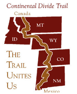
This week, sadly, the organization which supported the Continental Divide Trail, one of the "Triple Crown," (Appalachian, Pacific Crest, and CDT) has disbanded for lack of funds. The agency which oversees the CDT is the National Forest Service.

The CDTA writes:
Increasing pressures from development in the West, rising land costs, and challenges with the longstanding down cycle in the economy threaten the completion of the Trail. Despite the strong level of financial support from so many of you, overall contributions and other revenues in recent years have significantly declined. These revenues are the life blood of nonprofit organizations like the CDTA.

Consequently, the CDTA Board of Directors has made the very difficult and painful decision to cease operations of the CDTA. The financial condition of the organization has been unstable and deteriorating for a number of years. We have not been able to raise the necessary financial resources to sustain the continued operations of the organization.
If you love a trail, please support it financially in any amount you can. The existence of an organization is not a given, even for a federally authorized trail.


See Continental Divide Trail

Thursday, January 12, 2012

Help NCTA Win $100,000 in Marketing Services

Vote at Vote for $100K in Marketing Services for NCTA

Yes, you read that right. This is a voter-decided charity where ten organizations will win $100,000 each in marketing services. Most of the charities are Michigan based (that's where the offer comes from).

I appreciate the little win that you readers all just helped me get, but this vote is much more important, and you can potentially help nine other non-profits as well as the North Country Trail Association. If you are not from Michigan, don't pass it by. There are groups that should appeal to you. Many are animal rescues, women and youth support, faith-based organizations, aid to the disabled and homeless, and lots more.

We just ask that you choose North Country Trail Association as one of your votes!

The list is alphabetical, so you'll find us between New Hope Center for Grief Support, and Novi Athletic Boosters. Just scroll down!

Check ten boxes, then scroll to the bottom and hit Submit.

If there was ever a time to rouse yourself to action this is it! Great benefit to NCTA, and an easy voting process. You do have to enter your name and email, but that's all- no complex sign-up. Vote one time; you're done.

Vote at Vote for $100K in Marketing Services for NCTA

Sunday, January 1, 2012

Winter Hike on the FLT/NCT

view from TenKate Bridge
view from TenKate Bridge (photo by Terry McConnell)

by Terry McConnell

What better way to end the calendar year than with a hike on the FLT? Earlier in hunting season I had "knocked off" the long road walk of M20 along Route 11 and W. River Road, and in early October I had hiked the eastern half of M19, returning to my car on Babcock Hollow Road along the orange blazed "Dabes diversion". That left the mostly-trail segment from River Road to the top of Virgil Mt still to be done. Together with the return trip, the leg would fall neatly into my 15-20 mile sweet spot, so I slung on my day pack and headed west and uphill from my car on River Road.

From River Road the trail heads steeply uphill along the scenic rim of a small river gorge, quickly to emerge smack in the back yard of somebody's house. "Sure hope they're members," I thought as I gingerly crept by within 5 feet of a picture window, trying my best to look like a normal part of the scenery. Further along I snapped a quick cell phone pic looking upstream at the Tenkate bridge, my shaky hands conspiring with the laws of optics to produce an interesting effect I never could have gotten with forethought.

Trail conditions can be summarized in one word: slippery! Above 1600 ft. there was a uniform 1-2 inch layer of slushy snow that required a kind of stiff-legged strut to navigate any grade steeper than 5%, and which made side hill traverses dicey and dangerous. On downhill stretches through Tuller Hill SF I worked to perfect a primitive form of 'skiing' on hiking boots made possible by this slick layer. The speed gained thereby partially made up for the slow-going, but nevertheless I emerged on Carson Road a good hour behind schedule.

Read the rest of Terry's interesting adventure at Finger Lakes Trail email group, and consider joining to always know what's going on.

This segment is on FLT map M19